Get out into the world and explore on one of Ritten’s six themed trails. The trails from the valley’s vineyards up into the lofty heights of Rittner Horn offer fun facts about the origins of the Sommerfrische, how the earth pyramids were formed, the life of shepherds in the alpine pastures, South Tyrolean myths, legends and folklore, and much more.
End: Schwarzsee Spitze, 2.069m
Trail sign: Panoramic way
Tour length: 2.863 m
Descent: 99 m
Ascent: 78 m
Tour duration: 45 min
Difficulty: easy walk
Highlights on the way: magnificent panorama of the Dolomites, Round Table, Dolomitoscope, natural mountain pine labyrinth, Kneipp basin
Next, the hike leads across the alpine pastures of Barbian (Barbianer Almen) to the mountain pine oil distillery, the mystical location in the “Pfannenstiehl” and finally to the highest point of the hike. From thence the tour moves across the alpine pastures of Ritten to the “Neue Berghütte”- the new mountain hut (not open to the public). Following the Heusteig track, lined with comfy spots to sit down and burbling wood troughs, you reach the Feltuner Hütte – popular refreshment and snack stop. From here it’s a short and easy walk back to the mountain terminal at Schwarzsee Spitze.
Read more
Following the indications for Oberes Horn/Corno di Sopra (2.260 m) we will arrive at the peak of the hiking tour. Walking back down along path N° 2, past the refuge “Berghütte” (2.090 m), until we hit N° 2A and the N° 19.
This is the way back to the mountain terminal of the gondola. Finally, we can walk trail N° 1 all the way back to Tre Vie (1.5 hours)
Live panorama webcam Cima Lago NeroRead more
This alpine pasture hike along the "Heusteig" leads from the mountain station of the Rittner Horn cable car from Schwarzseespitze towards Unterhorn and on to Gissmann, the highest settlement on the Ritten. We follow the wide alpine path (19 and 1), past the Unterhornhaus to in front of the Feltuner Hütte. This is where the actual "hay trail" begins, which was once used by the Ritten shepherds in early summer to bring the first "mown" to the hay hut (Schupfe) a little lower down. The "Heusteig" marked 2A leads past two water troughs with good drinking water and joins hiking trail 2 just after a hay hut. From here you can climb about 50 metres in altitude via an unmarked trail to the vantage point at Gissmanner Nock (1,924 m).
Hiking trail 2 descends steadily to Gissmann. Then walk the 5.3 km along the traffic-calmed access road from Gissmann to Pemmern in about 1.5 hours. Hiking bus timetable
Interesting facts about mountain hay: The production of hay is still of great importance today. The meadows at lower altitudes produce the first hay as early as June. The mowing of the mountain hay, an extremely nutritious animal feed consisting mainly of herbs, begins somewhat later.Read more
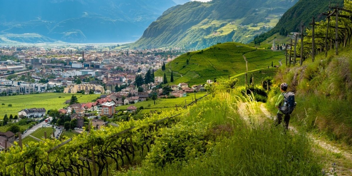
On the sun-kissed slopes, ventilated by the mild wind of the Ora, which stretch up from Bolzano to Ritten, viticulture has a long tradition. With 132 hectares of cultivated land, Ritten is one of the larger wine-growing communities in South Tyrol. This has prompted us to create a wine hiking trail in the form of an "artistic wine staircase" through the diverse terroir. The beautifully laid out hiking trail runs through the cultivated vineyards of the farmers of Signat and St. Justina to Rentsch and should also be understood as a living sign of cooperation between tourism and agriculture.
The "Rebe" wine trail is about 3.5 km long and begins in the descent from Signat on the Ritten (850 m) and ends in the provincial capital of Bolzano in the district of Rentsch (350 m). Walking time approx. 70 minutes. Sturdy walking shoes are required. Along the "wine staircase" there are about 500 metres of altitude to climb, with ten artistically designed installations along the way depicting the different vineyard locations, the varieties and forms of cultivation, as well as the historical aspects of viticulture.
"When you realise how great the achievement of nature and man is to produce a single drop of wine, the pleasure of entering nature and enjoying a glass of wine is all the greater. My art is meant to help awaken the senses."
Artist and sculptor Filip Moroder Doss
From the mountain station of the Rittner cable car in Oberbozen, follow the signs for hiking trail 23 or "Erdpyramidenweg" (earth pyramid trail) to the junction of trail 26 and then continue down this trail onto the "Keschtnweg", which leads further to Unterinn and Siffian. From there, take hiking trail 11 to Klobenstein to the station of the Rittner Bahn, which runs every half hour on the hour '06 and '36 back to Oberbozen, with an hourly service in the evenings from 7.06 pm. Last departure at 10.20 pm.
Walking time: 4 to 5 hours
Altitude difference: Descent: 830 m / Ascent: 779 m
Refreshment stops along the Keschtnweg: Buschenschank Partschonerhof, Gasthof Fleier & Wunder, Gasthaus Pirbamer and Buschenschank Rielingerhof.Read more
Once you arrive at the mountain station, it's only a few steps to the panoramic tower. If you climb up there, you will have a great overview, just like Toni...
And what does Toni think belongs in a legendary adventure world? A huge eagle's nest, so big that it is already a labyrinth, a water world with Kneipp basins and water channels for splashing and playing, climbing possibilities, fabulous views, exciting insights into another world ... But come and experience it yourself! One thing we can tell you already now: it never gets boring with Toni!
And we promise: You don't have to go far, the way through this fabulous world leads from the mountain station Schwarzseespitze to Unterhorn. While you enjoy the world of Toni, there are enough resting places for your parents to enjoy the panorama. But maybe they will find it more exciting to take part in the legendary adventure games...
Length of the circular walk: approx. 2 km
Start: mountain station Schwarzseespitze - Unterhorn - mountain station SchwarzseespitzeRead moreMore information
With Pyramix we follow the tracks of the wild animals on the sunny high plateau Renon. The nature experience trail with the marking no. 16 leads us from Soprabolzano through woods and meadows over the village from Soprabolzano past to the farm Lobis and its mill.
At the beginning of the trail Pyramix welcomes us and tells us a lot about the wildlife on Renon. Curiosity is already aroused and off we go!
We already see the first coloured spots between the trees. What could this be? ...It is Fiona, the clever Mrs. Fox. Here in the forest she has found a great place for her earth.
The path leads us further to Ivo, a companion with a spiky hairstyle, which you can find especially at night while looking for food. Well, which animal do you think is meant?
Again and again we pass various forest and meadow inhabitants. Whether it's Walter, the busy woodpecker, who hammers a cave for his chicks into the tree, or Sissi, the busy squirrel, who collects his stocks.
At each of these stations, children will find great opportunities to play and learn about the characteristics of the animals in a playful way, and of course there is also a description of the wild animal with its special features.
Entertainment and fun for young and old are therefore guaranteed.The nature trail is simply FUNtastic!
Start: Soprabolzano/Oberbozen station for rail way & cable car Renon.
Long: about 3,6km
Read moreMore information